 BOSTON's BEST KEPT SECRET?
(MBTA ORANGE LINE: Back Bay Station, Mass Ave, Ruggles, Roxbury Crossing, Jackson Square, Stony Brook, Green Street, Forrest Hills)

UNFINISHED BUSINESS & THE HISTORY OF THE SOUTHWEST CORRIDOR PARK
Running From Back Bay Station to Jamaica Plain this ribbon

park runs along the right of way created in anticipation of a highway project that was conceived in the 1940's and killed by the unified communities of Cambridge and Boston who opposed the highway that would destroy their neighborhoods. Although a right of way had already been razed a united association of grass roots community groups lobbied their representatives and the governor of Massachusetts to end the era of urban renewal projects which destroyed inhabited communities in Boston. They were sacrificed on the alter of highways, suburbanization, and sprawl. The dramatic Southwest Corridor battle marked a policy shift and the birth of a kind of community activism that has continued ramifications today. This battle, along with the Big Dig, was a unified expression by citizens in

urban neighborhoods who knew what highways and urban renewal had meant for other neighborhoods in Boston and New York. Now their voice was as loud and important as the voices asking for growth outside of the city. These voices were asking for bedroom communities, residential enclaves, and were also engaging in speculative housing, industrial and office developments. Now the funds that had been granted for the highway would be used instead for the things that urban communities need. A huge investment in public transportation extended the orange line much deeper into the Boston neighborhoods. Deeper into Roxbury and Jamaica Plain

all the way to Forest Hills along with a ribbon park and pathway for pedestrians and cyclists, a series of playing fields, playgrounds, housing developments, and a promise that the vacant lots cleared for the highway would be developed by the consent of the people and offer economic opportunities. The filling of this urban vacuum is an excellent thermometer to measure Boston's blood sport development politics. Projects conceived in partnership with the neighborhoods dominated in the early years as the Boston Police Headquarters, Roxbury Community College (RCC) and the Whittier Street Health Center, to name but a few, were conceived and brought to fruition. Housing developed by community development corporations (CDCs) was built, notably by Madison Park CDC, which symbolically took its name from the civic organ of the Lower Roxbury Community which had been removed and replaced by Melnea Cass Blvd. The properties cleared for the Southwest Corridor were divided into parcels, distributed by public agencies and in too many cases lays vacant still. Political clout, and popular support are a major factor in the development of these public parcels and so many projects have been conceived without financial viability, and in come cases built anyways. The was the case for Parcel 18 at Ruggles Station, a large swath of land that has had a master plan called

Ruggles Center completed decades ago and implemented

in phases over the years with varied success. First a parking garage and office building of ten stories was built on the site, before the plan went bankrupt and was bought at the request of the developers, by Northeastern University, a neighbor with deep pockets and a long term interest in seeing the neighborhood blossom. After year of wrangling, Northeastern opened a 500,000 square foot university facility with 1200 student beds, a coffee shop, art gallery on public display, state of the art cafeteria and a pair of towers rising over twenty stories into the air and marking a distinct change in the politics of land development along the Southwest Corridor. Policy has been opposed to letting rational economic forces of real estate development shape the corridor. Instead government interventions were designed to cede much control to the community and promote empowerment.

In recent years Northeastern University has also developed the first housing project consisting of both undergraduate students and affordable home ownership on the same parcel, marking a first in the nation. The university has also proposed development on Parcel 3, a nine acre vacant lot sitting unused across from Police Headquarters on Tremont Street. This proposal was rejected by a community process in favor of the proposal by Elma Lewis Partners, a corporation created by the National Center for Afro-American Artists and envisioned as a mixed-use development

consisting of a museum, school of fine arts, new facility for Whittier Street Health Center (currently hosted by Northeastern on Parcel 18), supported financially by retail, housing and offices. That project currently is surrounded by doubt and has become a political football. With Northeastern waiting in the wings the latest on the project is that Whittier Street health center will use American Recovery and Reinvestment Act (ARRA) funds, better know as 'the Stimulus', to begin construction on Parcel 18 of a new headquarters, while the rest of the project continues to seek funding in a lending climate that isn't very favorable to mixed-use development projects.

Other public parcels still in play are around Jackson Square and Roxbury Crossing and await the political and financial climate necessary for development, hopefully as beacons of sustainability and sounds policies for the 21st Century like business incubation, office sharing and to take advantage of the nearby hospitals, universities and research centers as well as taking advantage of community activism.
These are the forces that have shaped and continue to shape a large swath of Boston running from the Back Bay, through the South End, Roxbury and Jamaica Plain.
THE SOUTHWEST CORRIDOR PARK: A WORLD CLASS PUBLIC SPACE
Although not as grand as the new Rose Kennedy Greenway running through downtown where Route 93 stood before the Big Dig, the Southwest Corridor Park is more beautiful and pedestrian

friendly along the stretch from the Back Bay through the South End and has tremendous potential along the less developed sections running through Roxbury. Neighborhoods like my own which are near the Southwest corridor are poised for a surge in popularity and price as continued development on formally empty parcels improves on the park. Northeastern's signature International Village Development opened in the fall of 2009 and included a handsome improvement to the park where it runs past Ruggles Station, creating a pleasant urban, pedestrian experience all the way to the vacant Parcel 25 across the street from Roxbury Crossing where a pedestrian is suddenly greeted with an experience reminiscent of the South Bronx in the early 80's.

Clear to those who know the Southwest Corridor Park, the development of Parcel 25 is key to the future of the Southwest Corridor Park.
The pedestrian/bicycling corridor runs all the way to Jamaica Plain from Back Bay Station, although it begins to feel disjointed after a spectacular stretch that runs through the South End.


First the pedestrian crosses busy Mass Ave, then after passing the Mass Ave T station spills out into a less articulated open space at Carter Park then running along Columbus Ave to Ruggles Station, where it once again becomes an intimate pedestrian experience at International Village. The newly connected segment running behind the police headquarters is quite nice, with basketball courts and a quiet half moon of amphitheater seating destined to become a hangout for students from Northeastern and Wentworth in the future. This is where the park is interrupted by the blighted and undeveloped parcel 25, which desperately needs to be developed to extend the beauty of the park that is absolutely striking where it runs through the South End and has been developed beatifically.

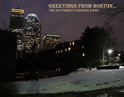
Like Central Park in New York, this man-made space brings a feeling of nature to the residents of the city, with an urban style and ironic beauty that, in my opinion, most natural wonders don't compare to. During the day the park offers urban dwellers grass, playgrounds, dog parks, tennis & basketball courts, gardens and views of varied architectural style from Victorian Brownstones and the meaty part of Boston's 'High Spine' of skyscrapers looming above. By night the park offers a quiet, contemplative place to walk, think or talk quietly while admiring handsome brownstones and a constellation Boston in Boston's Back Bay skyline. Of course being in the heart of a large metropolitan city you can also observe varied

oddities of the city along the Southwest Corridor Park. I've seen a group of small Asian women speaking in their native tongue stripping a small, well landscaped bush, of it's leaves and stuffing them in a bag. What for I don't know, food perhaps, stuffing for a cushion? I've also encountered people who were talking to themselves, sometimes angrily, sometimes in a loud prayer of forgiveness to their lord. These interesting and unexpected encounters, along with the striking urban beauty make the Southwest Corridor Park one of my favorite spaces in Boston.
More Images from the Southwest Corridor Park, fit for cards or prints, can be found on my store...


 there and Martin Luther King Jr., among others, has spoken. For night life check out 'the alley' on Boylston Street along the Boston Common. And Downtown Crossing has also began to wake up after years of quiet nights, with newly restored theaters, and and a steadily growing nightlife as a growing number of pioneers join the students and homeless in the neighborhood.
 medical history, and burying grounds along Tremont Street where you can follow the freedom trail deeper into old Boston.Take a break while walking through the Boston Common at the soldiers and sailors civil war monument. The column is covered in sculpture and raises 126 feet on top of a hill, providing a great place to sit and gaze upon the city lights and sights.
 ou.
ou.


 of
of 


